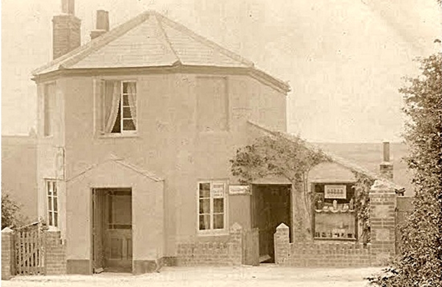
The old toll house on the west side of the A379 Teignmouth Road, stands at the junction of Claddon Lane with the A379 some fifty yards from Ridge Road and the former position of the black and white Solomon’s Post (also cited as without the possessive case apostrophe) sign. An early photo (below) shows the open porch (lower left) – now blocked off – (at the advent of motor vehicles in the early 20th century) and the blanked out toll-board recess (top right). Under the angled roof on the right, there was a small shop and working post office. The building probably dates from 1827 when the new turnpike road was built to augment the newly built Shaldon bridge. It was originally named Solomon’s Post Gate when there was a gate across the road for the toll collector to open upon payment.
The Stokeinteignhead Parish tithe map of 1845 reveals the toll house listed as a cottage under the ownership of the Turnpike Trustees and occupied by one Squire John.
The somewhat tenuous Jewish association of the name ‘Solomon’s Post’ has been postulated by Charles George Harper (1863-1943) in his splendid ramblings of ‘The South Devon Coast’. They can be supported to a certain extent by the Reverend Dr Bernard Susser in his ‘Social Acclimatisation of Jews in 18th and 19th Century Devon‘ where he states that ‘Jews began to settle in Devon from about 1730 and continued to arrive for the next 70 or 80 years‘.
A law was passed in 1648 requiring each parish to place guide posts at its crossroads, but it was not until after the General Turnpike Act 1773 that these ‘guide post’ or ‘fingerposts’ started to appear in substantial numbers.
The Solomon’s Post sign was a single post carrying no direction ‘fingers’ and its relevance of being more than just a mere guide post is assured by the vertical legend of ‘Solomon’ inscribed thereon.
The term ‘post’ may also bear reference to the location being a horse-point for the passing and delivery of mail. Alan W Robertson in his concise treatise entitled ‘Great Britain Post Roads, Post Towns and Postal Rates 1635-1839‘ describes horse-post communication:
‘Towards the end of the 17th century a very comprehensive network of horse-post communication had developed, and salaried postmasters had been appointed to the main and rural post towns (Torquay and Totnes being our representative post towns). Apart from the human frailties of some of the postmasters and letter-carriers the main problem was the provision of horses. The vision of swift horsemen riding with the mail like Dick Turpin across the countryside hell-bent for destination is pure fancy. Urgent Royal despatches and important mails travelled “haste post haste” embellished with the sign of the gallows as a warning of the fate of anyone causing delay. But the “ordanrie” or “publick mayle” travelled at a very unspectacular speed, often at only three or four miles an hour because of the type and condition of the horses procured by the local postmasters, who came in for frequent admonishment from the authorities in London’.
The establishing of Solomon’s Post is difficult to pinpoint accurately but may fit within a time period of late 17th century up to perhaps the mid 18th century.
In the Parish tithe reports of September 1845, no mention can be found of a ‘Solomon’ though research is hindered by not knowing whether it was a first name or surname (both being possible).
My article ‘Seven Several Roads’ at Solomon’s Post (full article and map fragment of 1805 posted at www.maidencombe.net) yields further information:
‘SEVEN SEVERAL ROADS’ AT SOLOMON’S POST
At the turn of the 19th century, Maidencombe or Minnicombe/Minicombe as it was named (and pronounced) on maps of the period, consisted of a few farms and even fewer dwellings. Solomon’s Post was the confluence of many routes, taking traffic from St Marychurch, Barton, Stokeinteignhead and Shaldon.
Such was its importance and location, Solomon’s Post became the site for a turnpike and the toll house that stands there today.
The origin of the naming is not certain, but a mid nineteenth century chronicler ventures that ‘the tolls on this turnpike-trust may have been farmed by one of those numerous Jews who took up that class of business’.
The following extract is courtesy of http://www.turnpikes.org.uk/ and was published in 1825 some two years before the Shaldon to Teignmouth bridge was opened and gives rise to the riddle of the names of these lanes and what happened to them.
‘and from thence across Watcombe Lane to Solomon’s Post, with One hundred and twenty Yards of each of the Seven several Roads which lead from or near to Solomon’s Post aforesaid, and from Solomon’s Post across several Fields to the Lane or Road which leads from Maidencombe Cross to Maidencombe Village, and from thence by Gabwell Common Hill to Stoke Common Hill, and from thence to the Town or Village of Shaldon,’
Prior to the construction of the turnpike (the A379 as it is today) in 1827, the state of the roads were poor indeed and transport communication consisted of horse and cart and riders on horseback along what were virtually narrow and muddied lanes.
When the rural signage was restored post WW2 by the authorities, it was seen fit to place a marker of Solomon’s Post (my recollection and reconstruction of the original post below) to preserve the historical location.

In the mid sixties, the wooden black and white sign posts were removed in Maidencombe by the council and replaced by metal signage.
A significant casualty was the non fingerpost at the junction with Ridge Road and the A379. It was a pyramid topped post in black and white bearing the legend ‘Solomon’s Post’ (see image).
SOLOMON’S POST NAME ASSOCIATIONS
Over the decades, Solomon’s Post has served as the hub for a dairy, shop, tea room and post office, all of which have now disappeared. The name has also prefixed other important landmarks and, as each one of them has been lost, the historical timeline inevitably fades from our collective memories.
A K6 telephone kiosk (production series ran from 1936-1968) was situated immediately to the north of the toll house on the sliver of land between Claddon Lane and the A379. Its location was stated as Solomon’s Post, Maidencombe. It was removed (along with the kiosk in Maidencombe car park) in the early seventies.
On March 4 1963, the local planning authority granted planning permission for a parcel of land off Ridge Road to be used as a caravan site (notwithstanding that the site had been used as a residential caravan site since about 1930), which came to be known as Solomon’s Post Caravan Park. Subject of several legal rulings, the site was cleared in the late eighties and the Solomon’s Post reference ceased to exist.
Before the construction of the bus lay by opposite Sladnor Park on the A379 Teignmouth Road, the designated bus stop was at this junction and it was named Solomon’s Post on the existing bus timetables (number 13 at that time). The current contract holder Stagecoach, now lists the stop as Maidencombe, Sladnor Park Road in their timetable, so already historical significance of the location is being lost.
Today, apart from ‘Solomons Post’ the private address of the toll house (which is not at the true location) no evidence exists of Solomon’s Post.
Jim Campbell